01 — Import
Drop the DJI file in
JPEG or DNG, Lightroom exports fine. Camera lat/lon, altitude, gimbal pitch and yaw come out of the XMP automatically.
DroneCallout reads position and gimbal angles from your DJI file, then snaps parcel boundaries onto the exact perspective you flew. Card to client-ready in under a minute per photo.
Free during beta·macOS 14+·iPad on the way
The workflow
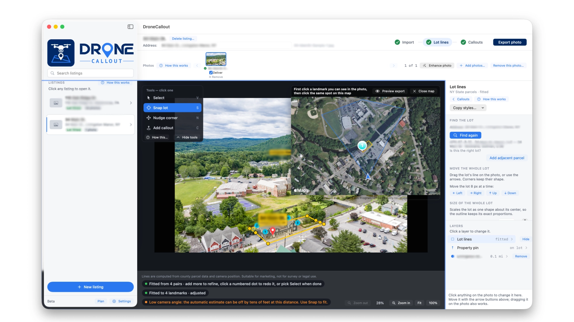
The whole pass fits in one Mac window. No plugin, no round trip through Photoshop.
01 — Import
JPEG or DNG, Lightroom exports fine. Camera lat/lon, altitude, gimbal pitch and yaw come out of the XMP automatically.
02 — Lot lines
Click four things you can see in the shot, click the same four on the satellite view. The polygon lands on the lot, in perspective.
03 — Callouts
Search a school, a park, a hospital. Each callout pin shows its miles from the property, not from the drone.
04 — Export
Full-resolution JPEG at the photo's exact pixel size, without a watermark or per-image charge. The disclaimer lives in the file metadata.
Why perspective shots
Most lot-line tools want a straight-down (nadir) shot. Real estate does not fly straight down. The shot that sells a house is 300 to 400 feet up with a shallow gimbal tilt. That is the shot the buyer wants to see.
DroneCallout does the perspective math for you. Gimbal pitch, flight yaw, camera altitude, ground plane. The polygon lands where the fence line actually is. Four snap points get you exact.
How the line gets there
Most lot-line tools work by tracing. You pull a reference image of the parcel from the realtor's listing sheet or the county map viewer, and you click points on your drone shot to match the shape by eye. On a rectangular quarter-acre lot with a shallow tilt, that works. On anything else, it falls apart.
DroneCallout pulls the actual survey polygon straight from the county database, then projects that exact shape onto your photo using where the drone was and where it was pointed. Every corner point the assessor recorded lands where it belongs. A flag lot's panhandle keeps the width it actually is. An easement cut-out stays cut out. A curved riverfront boundary follows the curve on the deed.
The four-point snap only fine-tunes the alignment. The shape itself is never up to you.
In the beta right now
One Mac window from import to export. State saves per listing, so a shoot picks up where you left it.
Reads camera position and gimbal angles from your DJI file's XMP. Draws the polygon in perspective before you click anything.
Tap a driveway corner, a fence post, a roof, anything you can also point to on the satellite view. Four pairs fit the lot exactly.
A teardrop pin lands on the house. A two-line address box floats above it, with the street on top and the city and state below.
Search a school, park, or hospital by category. Each pin shows miles from the property, not from the drone position.
Colors, box fill, text size, corner rounding, leader line, all styled independently from the lot line. Save as a template and reuse it across the agency.
Add adjacent parcels with one click. Each extra lot draws through the same fit and stays a separate polygon.
One listing holds every shot from the shoot. Address, lot polygon and callout places stay listing-wide; each photo gets its own snap.
JPEG at the photo's exact pixel size, without a watermark or per-image fee. The not-for-survey line lives in the file metadata, never on the photo.
Swaps a gray or overcast sky for a clean blue. The ground stays untouched, pixel for pixel.
A stacked list of the schools, train stations and shopping the buyer wants to know about, even when they aren't in the shot. Search by category and tap add.
The address box adds a third line for the acreage, under the city and state. Type a survey number to override.
A small compass in the corner points to true north. Buyers see which way the back deck actually faces.
Puts your studio's name or logo on every export. Text or image, in any corner.
Pick fill, text color, opacity and corner rounding once. Address label, callouts, info bar, acreage and watermark all match.
Coverage
The app ships with the public parcel coverage we already use for our own shoots at Nimble Dragon. Everywhere else lights up as the beta grows. National coverage on Regrid switches on once subscribers cover its monthly floor.
Sign up and tell us where you fly. Your area is how we decide what to add next.
Free at launch
All 38 counties published to the state parcel service, including Sullivan, Orange, Ulster, Dutchess, Delaware, Westchester and the five boroughs.
Free at launch
Direct from the county GIS. Milford, Matamoras, Lackawaxen and everywhere in between.
Coming with the beta
Nationwide coverage rides on Regrid — we switch it on as beta subscribers cover its monthly floor. Fastest way to move your state up the list is to sign up.
Any DJI drone whose photos carry GPS and gimbal data in the XMP. Needs an internet connection for parcel lookup, nearby places and SkyFix. iPad on the way.
Request access
Free while the beta is running. We'll invite you the moment your area lights up.
We reply within one business day. Your email stays with us and off every list.